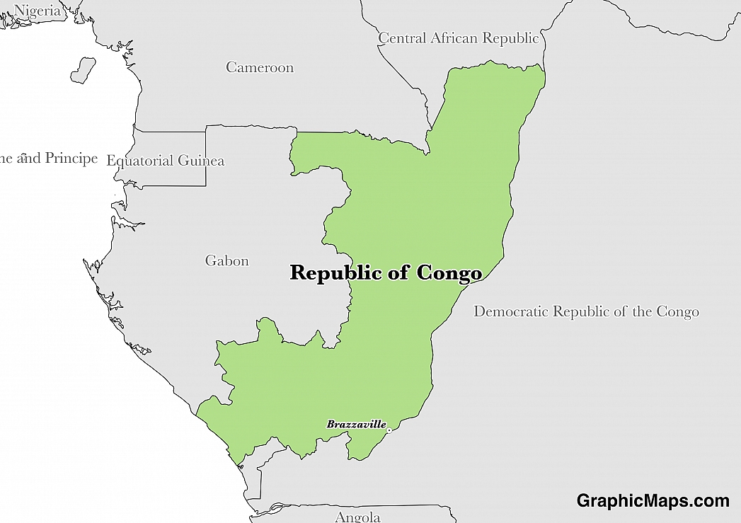
Where is Republic of the Congo?
Located in Central Africa, Republic of the Congo has a 5,008.00 km border with Angola (231 km), Cameroon (494 km), Central African Republic (487 km), Democratic Republic of the Congo (1,229 km) and Gabon (2,567 km). It has a 169.00 km coastline. The location of the boundary in the Congo River is undefined with the Democratic Republic of the Congo.
The capital city of the Republic of the Congo is Brazzaville which is located on the northern side of the Congo River, opposite the capital of the Democratic Republic of the Congo, Kinshasa. During the Scramble for Africa, the city was settled by French colonialists in 1880 and remained a colony until 1960. In order to distinguish the two Congo countries, the Republic of the Congo is often called Congo-Brazzaville. The population of Brazzaville was last estimated in 2014 at 1.83 million people living in an area of 269.2 square kilometres (101.9 square miles). Over one-third of the entire population of the country live in Brazzaville and the city is home to 40% of non-agricultural employment in the Republic of the Congo. Much of the population relies on the Congo River in order to make a living in the shipping, industrial, manufacturing, or trading industries. The climate of Brazzaville, much like Kinshasa, is considered a tropical wet and dry environment with the rainy season lasting from October-May and the dry season running from June until September. The dry season in the Republic of the Congo and neighbouring countries is shorter than many other African nations. The average high throughout the year is 30.2 degrees Celsius (86.2 degrees Fahrenheit) and the yearly average low is 20.7 degrees Celsius (69.3 degrees Fahrenheit).
Read more on Republic of the Congo's CapitalRepublic of the Congo is an African country covering 342,000.00 km2 of which 0.15% is water and 341,500.00 km2 is land. This makes it the 63rd largest country in the world and slightly smaller than Montana. Its geographic coordinates are 1 00 S, 15 00 E and Brazzaville is the capital city.
The congo is named for the Congo River, which lies on its eastern border.
Its ISO code is CG.
Geography
Republic of the Congo has a mean elevation of 430 m above sea level.
It has a tropical climate with a rainy season from March to June and a dry season from June to October. Its terrain consists of a coastal plain, southern basin, central plateau, and northern basin.
Population
Republic of the Congo has a population of 4,852,412 making it the 124th largest in the world.
French is the official language; Lingala and Monokutuba are widely spoken. The majority ethnic groups are Kongo, Sangha, and M'Bochi. The majority of the population identifies as Christian.
The official language of the Republic of the Congo is French which is a reflection of the past colonial history of the area. The modern French language evolved from the Romance period of Indo-European languages of the 7th to 9th Century. There are 26 countries in the continent of Africa that recognize French as an official or national language and millions of African citizens speak it as their first or second language. National languages in the Republic of the Congo include the Lingala and Kituba languages, both of which are recognized and used in surrounding nations. Lingala is a Bantu language and the majority of speakers live in the neighbouring Democratic Republic of the Congo (approximately 7 million out of 10 million). Kituba is a Kongo-based Creole language which is based on Kikongo. Other languages used in the country include Bateke, Mboshi, Pygmy, and around 40 additional methods of communication. The population of the Republic of the Congo receives education at all levels in French and the country has produced many writers and poets that are known in both the African and French communities. From the 5.2 million people living in the country, 88% over the age of 15 can write and speak simple phrases in French. The language is spoken by 30% of the population on a daily basis.
Read more on Republic of the Congo's LanguagesThe dialing code for the country is 242.
Government
Republic of the Congo is an independent country. It became independent from France in 1960. Its constitution was last ratified in 2005.
The political system of the Republic of the Congo is considered a unitary, semi-presidential republic since the 1992 constitution. The country experienced one-party Marxist/Leninist rule from independence in 1960 until the 1992 multi-party elections. Executive power is held by the President and the ruling government. Legislative power is held by both government and the parliament. The Senate of the country holds elections every two years for approximately one-third of its 72 members. The elections for the National Assembly take place every five years for the 139 seats available.
Read more on Republic of the Congo's GovernmentEconomy
The currency of Republic of the Congo is the Franc (XAF).
Its major export partners are China, Italy, and India. Its main exports are petroleum, lumber, and plywood. Its major import partners are China, France, and South Korea. Its major imports include capital equipment, construction materials, and foodstuffs.
Flag
The flag of the Republic of the Congo consists of a central yellow band that divides a green triangle in the upper left-hand corner and a red triangle in the bottom right corner. This flag was officially adopted on 15 September 1959, before the country gained independence from France in 1960, but was replaced in 1970 with the flag of the People's Republic of the Congo which lasted until 1991. This original flag of the Republic of the Congo was readopted on 10 June 1991 and remains the national flag today. The yellow band is a symbol of friendship and nobility of the people who live in the country. The green triangle is representative of the abundant agriculture and forests of the nation. Although the red color has not been officially explained, it completes the Pan-African color scheme of the flag which is popular in many other countries of the area. The 1992 Constitution of the Republic of the Congo states design specifications and proper usage. This flag was given official approval from the National Assembly (parliament) of the country on 18 August 1959 and adopted just under a month later.
Read more on Republic of the Congo's FlagThis page was last modified on January 17th, 2018
More on Graphicmaps

Published on 2019-11-06
What is a Trade Embargo?
Published on 2019-11-04
Which Two Countries Used to Have the Same Flag?
Published on 2019-09-16
What Is the Only Two-Sided State Flag?
Published on 2019-09-16
Which Country Flag Looks Like the Texas Flag?
Published on 2019-08-29
Flags That Resemble the US Flag

Published on 2019-08-20